Obolus for project support
If the Freizeitkarte project does something good for you maybe you can think about supporting us a little. Regard this as an invitation to "a cup of tea and cake".
Donation option by transfer to a German bank account
Account holder: Klaus Tockloth
Bank: Volksbank Münster eG
BIC: GENODEM1MSC
IBAN: DE48401600501701199600
Donation option by transfer via PayPal
Thanks for your support - you are helping us to continue the project.
Statement according to section 5 of the Telemediengesetz (TMG)
Klaus Tockloth, Im Seihof 34
D-48161 Münster, Germany
eMail: freizeitkarte@googlemail.com
On the Freizeitkarten project are active working:
- Johannes Hahn (routing)
- Roman (Winter sports, map design "outdoor")
- Christian Kraemer (server administration)
- Patrik Brunner (development, server administration)
- Stephan Brugger (map design "outdoor-contrast")
- Stephan Oppermann (map designs "contrast" and "small")
- Klaus Tockloth (development, map design "freizeit")
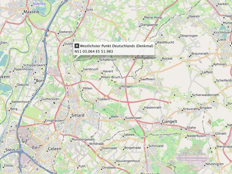
Map representation in BaseCamp: The westernmost point of Germany marked by the boundary markers No. 309 B in the Gemeinde Selfkant.
Disclaimer / Notice of liability for links / Privacy protection policy / Copyright
Due to German regulations this part of the 'about section' is very special and only available in german.
German 'Impressum'
DSGVO
These websites do not collect, store or process any personal data.

Map representation in BaseCamp: The easternmost point of Germany between Deschka und Zentendorf.
Use of the maps
The use of maps is at your own risk. The map data and / or the routing may contain errors or may be insufficient. The creators of these maps are not liable for any damage resulting
directly or indirectly from the use of the maps.
License conditions of the map data
Map data © OpenStreetMap contributors (ODbL). All maps are based on data from the OpenStreetMap project. OpenStreetMap is a free editable map of the whole world that is created by people
like you. OpenStreetMap allows geographic data to look at collaborative way from anywhere in the world and edit it.
Link: www.openstreetmap.org/
License: www.openstreetmap.org/copyright/en
License conditions of the elevation data
The contour lines are based on different sources, depending on availability.
Data provider name: Various (compiled by Sonny)
Data provider homepage: sonny.4lima.de/
License type: CC BY 4.0
License string: sonny.4lima.de - SONNY's LiDAR DIGITAL TERRAIN MODELS (DTM) OF EUROPEAN COUNTRIES, CC BY 4.0
Data provider name: U.S. Geological Survey
Data provider homepage: usgs.gov/centers/eros
License type: Public Domain
License string: U.S. Geological Survey (public domain), eros.usgs.gov
Data provider name: JAXA (Japan Aerospace Exploration Agency)
Data provider homepage: earth.jaxa.jp/en/
License type: CC BY 4.0
License string: AW3D30 - JAXA (Japan Aerospace Exploration Agency), CC BY 4.0
License conditions of the maps
Produced map © FZK project. The available maps are a derived work from map and elevation data. The maps can be used free for any purposes.
Provision of OpenStreetMap data
Daily updated country- and region-specific extracts of the OSM database data are provided by the company Geofabrik GmbH (Karlsruhe, Germany).
Link: www.geofabrik.de
Creation of the maps
All maps were created using the tools "osmfilter, osmconvert, splitter and mkgmap".
Link: wiki.openstreetmap.org/wiki/Osmfilter
Link: wiki.openstreetmap.org/wiki/Osmconvert
Link: https://www.mkgmap.org.uk/
License: 100% free and open source (LGPL3 license)
Creation of the contour lines
The contour lines were created using the tool "phyghtmap".
Link: github.com/agrenott/pyhgtmap
License: GPL-2.0 license
Trademarks
Garmin® is a registered trademark and BaseCamp™ is a trademark of Garmin Ltd. (www.garmin.com) or its subsidiaries.
Mac OS® is a registered trademark of Apple Inc. (www.apple.com).
Windows® is a registered trademark of Microsoft Corp. (www.microsoft.com).